r/geology • • 26d ago

Identification Requests Monthly Rock & Mineral Identification Requests

3 Upvotes

Please submit your ID requests as top-level comments in this post. Any ID requests that are submitted as standalone posts to r/geology will be removed.

To help with your ID post, please provide;

  1. Multiple, sharp, in-focus images taken ideally in daylight.
  2. Add in a scale to the images (a household item of known size, e.g., a ruler)
  3. Provide a location (be as specific as possible) so we can consult local geological maps if necessary.
  4. Provide any additional useful information (was it a loose boulder or pulled from an exposure, hardness and streak test results for minerals)

You may also want to post your samples to r/whatsthisrock or r/fossilID for identification.


r/geology • • Dec 01 '25

Identification Requests Monthly Rock & Mineral Identification Requests

8 Upvotes

Please submit your ID requests as top-level comments in this post. Any ID requests that are submitted as standalone posts to r/geology will be removed.

To help with your ID post, please provide;

  1. Multiple, sharp, in-focus images taken ideally in daylight.
  2. Add in a scale to the images (a household item of known size, e.g., a ruler)
  3. Provide a location (be as specific as possible) so we can consult local geological maps if necessary.
  4. Provide any additional useful information (was it a loose boulder or pulled from an exposure, hardness and streak test results for minerals)

You may also want to post your samples to r/whatsthisrock or r/fossilID for identification.


r/geology • • 15h ago

Wondering what these “orbs” are?

Thumbnail
gallery
186 Upvotes

I’ve found “clay babies” before wondering if these are like “fossilized” clay babies? Variety of sizes from the size of a quarter up to what you can see in the pictures. Broke them open and nothing of note inside. Found possibly a clam shell fossil with this but hard to say if it was just the way the rock broke. Near the kispiox river in British Columbia.


r/geology • • 6h ago

Familiarity with geology in Ellensburg WA?

Thumbnail
gallery
33 Upvotes

Saw this outcrop at Manastash Vista Point off of I-82 East in Ellensburg, WA. I didn’t have much time to look, just got out to help my toddler use the bathroom and kept moving. Took a few pics. Wondering if anyone knows about the contacts within the basalt. I’m curious about the clastic (sedimentary) dike with bedding, and the yellow/green rocks above the clastic dike (at the base of the basalt nearest ground surface. Pics posted.

Edit: I called the strata with bedding a clastic dike. Please forgive my error, as a clastic dike wouldn’t include bedding. I’m puzzled by this feature…it doesn’t appear to be soft sediment deformation so how would sandstone bedding like this end up truncated above and below by basalt?


r/geology • • 1d ago

Kīlauea Episode 43

Enable HLS to view with audio, or disable this notification

610 Upvotes

r/geology • • 21h ago

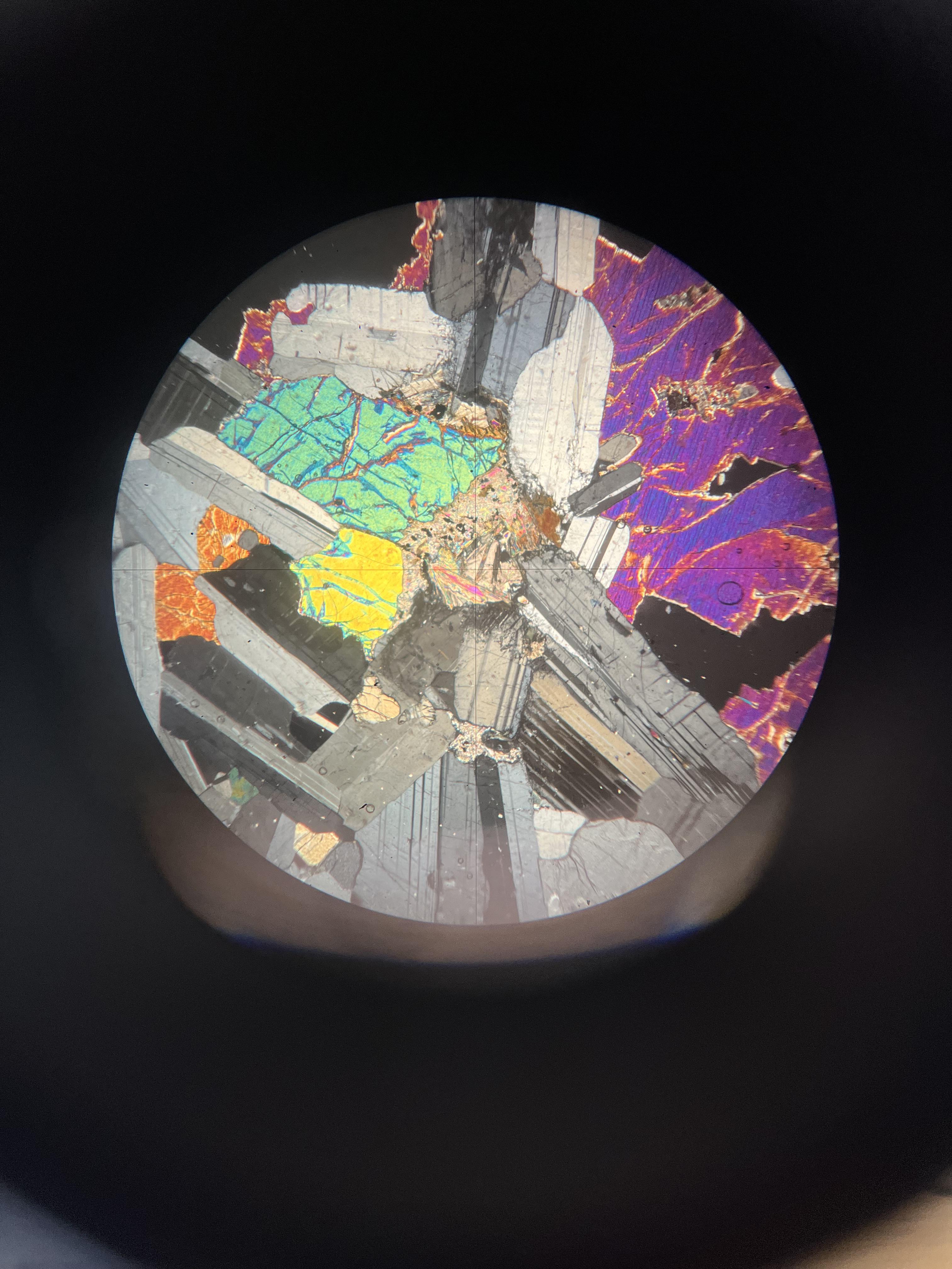
Thin Section What mineral is this?

Post image
79 Upvotes

Bit stuck on what this thing in the middle is can someone identify it please thank you! (igneous rock containing plag, cpx, olivine)


r/geology • • 10h ago

How do these form?

Thumbnail
gallery
9 Upvotes

I live near the foothills in Colorado, and have a very interesting backyard. We have lots of sandstone concretions and quartz. I’m used to seeing bowl shaped deformities in all sorts of rock types caused by natural erosion, but many of these are very deep and narrow, and some have progressed all the way to form tubes. Picture 2 is about 6 inch deep with a 1X2 inch opening. pictures 3-5 are about 18 inches long with a hollow and fairly uniform center, like a straw. I’m guessing this was some sort of very soft cylindrical concretion that eroded out leaving the harder outside sandstone? Either way very cool to see these all over the place!


r/geology • • 11h ago

Map/Imagery Circular structure, western side of Saudi Arabia

Thumbnail
gallery
11 Upvotes

What is it? How did it get its form? And does it have a name?

Furthest I've gotten is that it's located in the Aseer Province of Saudi Arabia. Labels are quite lacking on Google Earth.

It is located at coordinates

19°08'20.1"N 41°58'26.9"E


r/geology • • 1h ago

What’s the composition/ deposition environment?

Post image
• Upvotes

My mother found this rock outside of Cappadocia in Turkey. She remarked that there are no shell fragments.


r/geology • • 1d ago

Good thing they backed up.

Enable HLS to view with audio, or disable this notification

516 Upvotes

r/geology • • 18h ago

Map/Imagery Where do I start?

Post image
7 Upvotes

Sorry if my question is simple! I'm a painter and I like to understand what I paint, but I've been having trouble doing research on rocks. Specifically what inferences I can make about a mountain side. For example I've been using Mount Jomolhari in Bhutan as reference for a piece I've been working on, and while a google search reveals that the majority of the mountain is made of schist, gneiss, and migmatite (I think), I've been having trouble identifying which of those rocks can be found in specific reference images I've been using. I'd love to be able to make inferences on the context of how a rock face was formed, how that impacted the current composition and color/value differences within it and so on. If any rock nerds could point me to some good places to start in terms of scholarly papers, articles, or even trustworthy youtube videos it'd be greatly appreciated!

I've attached an example of a reference image I've been using. If you were me how would you go about analyzing an image like this?


r/geology • • 1d ago

Meat the Mealy Mountains...

Thumbnail gallery
47 Upvotes

This may be part 1 of... let's not get ahead of myself. I'm new here, even though I'm anything but.


r/geology • • 5h ago

Field Photo is it metoride ?

Thumbnail
gallery
0 Upvotes

Hi everyone, I found a palm-sized stone in a field near Hatay, Turkey, at around 400 meters altitude. There is no nearby water source. It feels heavier than a typical stone of the same size. The outside has rust-colored patches, and the inside looks lighter, whitish. A magnet, sticks only weakly. Could this be a meteorite, or is it more likely a terrestrial rock or slag? Photos attached.


r/geology • • 1d ago

Table Tooth Root Canal

Thumbnail
gallery
72 Upvotes

I've been looking up at this Mt. for over a decade wondering about this feature and yesterday I finally made it there. If you are familiar with the Catalina Mts. this is Table Tooth Mt. Viewable from most of Oro Valley, Marana and the Town of Catalina and is situated just North of Table Mt. It was about 5 hours of nasty bushwhacking while gaining 2,000' of elevation, but man was it cool. You can see some sort of large intrusion cutting through the landscape and continuing up the 500' cliff face. I know the intrusive history of the Wilderness Suite Granite is complex so I'm not going to start to try and analyze it as I'm just a novice.


r/geology • • 1d ago

Map/Imagery Personal Project: A 3D Hypocenter Atlas of the Earth

Post image
12 Upvotes

I've been working on a little side project called Hypocenter Atlas — an interactive 3D globe that plots earthquake locations by latitude, longitude, and depth.

You can view it here: https://hypocenter-atlas.netlify.app/

The idea was to get beyond the usual flat earthquake maps and see what the seismicity looks like in three dimensions. When you start exploring the globe, some of the patterns are pretty interesting, particularly around subduction zones where earthquakes extend deep beneath the surface.

The project includes historical shallow and deep earthquake catalogs, along with a mantle tomography layer to explore alongside the seismicity.

A fun part of this project is that I built it using AI-assisted coding, with Three.js doing the 3D visualization. I've spent a fair amount of time debugging the data and getting everything to line up properly.

I'm not a geologist, so I'd genuinely love feedback from people who know the science better than I do.

What patterns would you look for, or what would you change to make this more useful for exploring Earth's interior?

I'm especially interested in whether there are features in the data that stand out to experienced geologists that a casual observer might miss.

r/geology • • 1d ago

myth or reality? Diamonts

Thumbnail
gallery
9 Upvotes

In my country there is a highly controversial geologist who is obsessed with diamonds. He constantly produces work about diamonds, yet he is the only one who ever sees them. Other professional geologists say that the samples he claims to have never existed. My question is: how can I really debunk him? I’m attaching the images of the diamonds he publishes in his articles. Is there any way to find out whether they come from an earlier source or from other publications, in case they are fake? These are the images of diamonds that he adds to his publications.


r/geology • • 2d ago

I built a tool that lets you click anywhere on a map to see visible mountains in 3D

Enable HLS to view with audio, or disable this notification

184 Upvotes

The idea is dead simple: click anywhere on the map, and it scans your line of sight and renders all the mountains visible from that exact point in 3D.
I initially built it because I always wanted to know things like:
Can I actually see the mountain range from this street / house?
Which stretch of a road trip has the best unobstructed mountain view?
What am I actually looking at on the horizon during a hike?
Attached a quick screen recording of the current demo. What do you guys think of the concept? Any specific features or use cases you'd want to see in something like this?

You can try it here https://showmeonmap.com/mountain-finder


r/geology • • 1d ago

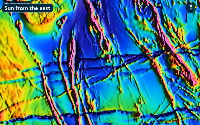
Map/Imagery Same magnetic grid, only the light moves. Lit from the north, the east-west dykes come through (Widgiemooltha dyke swarm, WA)

Post image
4 Upvotes

r/geology • • 1d ago

Field Photo Look at these cool rocks i found

Thumbnail
gallery
13 Upvotes

Livin next to a construction site in the niagra escarpment in ontario. Decided to go look for cool rocks and this is what I found. No idea what they are, dont care, thought they was cool and wanted to share.


r/geology • • 1d ago

Information Why is Zealandia often called a continent?

38 Upvotes

The land mass underneath New Zealand named Zealandia is often called a “lost continent” but the land mass (to my understanding) is smaller than Australia and if the land was above sea level wouldn’t it just be considered a larger country within the Australian or Oceanian continent?


r/geology • • 2d ago

Field Photo Silicafied Stromatolites or Banded Chert?

Thumbnail
gallery
38 Upvotes

Found in the Yellowstone River in NE Montana (not Yellowstone park)


r/geology • • 2d ago

Field Photo Merced river walkthrough 🪨

Enable HLS to view with audio, or disable this notification

53 Upvotes

Walktrough Merced river basin today.

Spectacular formations and beautiful views from river canyon, could be slate/shchist formations, also found few pieces of green mica (Mariposite).

If you ever drive through highway 49 from/to Mariposa, check out surrounding rock formations, you won’t be disappointed.

Hydrothermal alteration is everywhere and a great example of Mother Lode gold belts mineralization style, some areas are extremely complex, melange zones, with enormous gaps and quartz/carbonate veinlets.

P.S. English is not my native language, I may make mistakes during my speech, don’t judge.

#geology #mariposa #exploration #geology #mininggirls


r/geology • • 2d ago

Just checking this is a natural formation right?

Thumbnail
gallery
130 Upvotes

A very popular rock wall with the alternative history crowd. The Montana Sage Wall.

Some think it's evidence to question the status-quo on the ancient history of the Americas and that it was built by a much earlier civilization.

From initial images to my rather untrained eye it does look very convincing...

...for about 5 minutes.

Picture 1 & 2 is the Montana Sage Rock Wall

Picture 3-5 alternative views that (to me at least) immediately debunk it.

Pictures 6 & 7 are other similar formations. Dartmoor and Joshua Park.

Just erosion in suspiciously uniformed patterns isn't it...


r/geology • • 1d ago

Exploration/Mining teams: How are you managing data flow between MX Deposit, ArcGIS, and Leapfrog without constant export/import hell?

0 Upvotes

Between drillhole logging in MX Deposit (or Datamine), updating surface mapping/tenement boundaries in ArcGIS, and pushing collar/survey/interval updates into Leapfrog, keeping data in sync across all three is a persistent bottleneck.

For those working with active drill programs:

  1. What’s your current pipeline to keep 2D GIS and 3D modeling up-to-date with new assay/logging batches?
  2. Where does your workflow break down most often (e.g., projection shifts, manual CSV exports, version control between field and modeling teams)?
  3. Does Seequent Central or Datamine's native ecosystem solve this for you, or are you still relying on manual exports and custom Python/FME scripts?

r/geology • • 2d ago

Tips on how to "think like a geologist"

53 Upvotes

Hi everyone,

I’ve recently started studying geology, and while the theoretical concepts make sense on paper, I’m finding it challenging to transition into "thinking like a geologist" in the field. Professors often encourage us to form hypotheses and draw conclusions on the spot, but looking at an outcrop can feel overwhelming, there are contacts, weathering rinds, and fracture networks running in every direction, and I struggle to piece together what they actually tell me about the area's history.

Beyond basic lithology and fractures, what other key field features should I train my eye to spot, such as cross-cutting relationships, deformation fabrics, way-up structures, or alteration zones?

Do you have any practical tips or systematic workflows for adopting that geological mindset and turning a messy outcrop into a coherent geological timeline?